History of Nauru:
Nauru is a small island nation in the western Pacific Ocean. The island has been inhabited by indigenous peoples for thousands of years. When Europeans arrived in the 1830s, the island was inhabited by 12 tribes. The introduction of alcohol and firearms is believed to have destroyed the peaceful life of the 12 tribes. Beginning in 1878, the tribes waged war on each other for his ten years. Germany gained control of the island in 1886. Ten years later, prospector Albert Ellis found Nauru to be rich in phosphate. Phosphate became an important export of the island.
After World War I, the island was administered by Great Britain, Australia and New Zealand. During World War II, Japan temporarily occupied the island. After World War II, the island became Australian territory. Nauru became an independent republic in 1968. Nauru has long suffered from environmental degradation caused by phosphate mining. Efforts have been made to repair the areas damaged by the mines, but have so far been unsuccessful.
Information about Nauru:
| Capital | no official capital; government offices in Yaren District |
| Population | 12,798 (Source: 2023 worldometer) |
| Major Cities | Arijejen, Denigomodu, Menen, Yaren District |
| Borders | Banaba of Kiribati |
| Gross Domestic Product (GDP) | $114 million (2017 worldfactbook) |
| Currency | Australian dollar (AUD) |
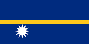
Flag of Nauru:
Nauru Economy Key Industries:
Nauru Major Industries: phosphate mining, offshore banking, coconut products
Nauru Agricultural Products: coconuts
Nauru Natural Resources: phosphates, fish
Nauru Major Exports: phosphates
Nauru Major Imports: food, fuel, manufactures, building materials, machinery
The Geography of Nauru:
Total Size of Nauru: 21 km² (source: wikipedia)
Geographical Low Point of Nauru: Pacific Ocean 0 m
Geographical High Point of Nauru: unnamed location along plateau rim 61 m
Climate of Nauru: Tropical with a monsoonal pattern; rainy season (November to February)
General Terrain of Nauru: sandy beach rises to fertile ring around raised coral reefs with phosphate plateau in center
World Region or Continent of Nauru: Oceania
Geographical Coordinates: 0 32 S, 166 55 E
The People of Nauru & Culture
Nauru Government Type: republic
Nauru Nationality: Nauruan(s)
Nauru National Holiday: Independence Day, 31 January (1968)
Nauru Independence: 31 January 1968 (from the Australia-, NZ-, and UK-administered UN trusteeship)
Nauru National Symbol:
Nauru National Anthem or Song: Nauru Bwiema (Song of Nauru)
Nauru Languages Spoken: Nauruan (official, a distinct Pacific Island language), English widely understood, spoken, and used for most government and commercial purposes
Nauru Religions: Christian (two-thirds Protestant, one-third Roman Catholic)
Interesting Facts about Nauru:
Nauru is a small oval island in Oceania in the western Pacific Ocean.
The origins of Nauru’s first inhabitants are still unknown. When Europeans arrived in the 18th century, Nauruan society consisted of 12 ancestral tribal groups, each with a chieftain.
Nauru does not have an official capital. However, government offices are located in Yaren District.
Nauru was originally named Pleasant Island when British navigator Captain John Farne passed through the island in 1798 on his way from New Zealand to the China Sea.
In terms of population, Nauru is her second smallest sovereign country in the world after Tuvalu. Technically, Vatican City is smaller, but it’s not a member of the United Nations.
In terms of area, Nauru is also her second smallest sovereign state in the world after Monaco. It is also the smallest country in the Pacific Ocean, the smallest country outside of Europe, the world’s smallest island nation, and the world’s smallest independent republic.
Nauru is one of 22 countries without an army.
Nauru is probably the least visited country in the world. There weren’t even enough visitors to make it into the World Tourism Organization’s latest report. By some estimates, only about 200 tourists visit Nauru each year.
Nauru has the fattest population in the world. A 2017 report ranked Nauru among the world’s most obese countries, with 88.5% of the population over the age of 18 classified as obese.
Nauru is her second most obese country in the world (Lorrie Graham/AusAID: CC 2.0)
11. Nauru has her second smallest Gross Domestic Product (GDP) in the world after Tuvalu.
Nauru has only 30km of roads. Only Tuvalua is shorter in terms of road length. Despite its small size,
Nauru has 5 km of railway lines. Used in phosphate mines to transport ore to dryers before being loaded onto ships.
Scientists believed Nauru would be uninhabitable by the mid-1990s, so again in 1963 and 1970 there was discussion of resettling all of Nauru’s population to an island off the coast of Queensland, Australia. The Nauruans rejected the idea and chose to remain.
Phosphate mining has ravaged central Nauru, turning it into a barren wasteland with jagged coral spiers 15 meters high jutting out from the ground. Centuries of mining have destroyed 80-90% of the land.
Phosphate mining resumed in 2005 when he discovered the presence of secondary phosphate. The government estimates that this secondary deposit will last for about 30 years.
Nauru was once technically the richest country in the world (per capita) thanks to its abundant and deep phosphate mines.
Nauru has been used by Australia as a detention center for asylum seekers since 2001. The conditions and treatment of asylum seekers are deeply debated and have been declared illegal by the International Criminal Court amid widespread allegations of human rights violations and overcrowding.
Nauru has never won a medal at the Olympics since it was first held in 1996.
In the 1990s, Nalua became a money-laundering haven, selling banking licenses and passports (including diplomatic passports, which each gave immunity up to $30,000). Customers included the Russian Mafia and al Qaeda.


