The area of what is now Equatorial Guinea has long been inhabited by indigenous tribes and pygmies. Spain took over the area during European colonial times and ruled it for about 190 years. In 1968 Spain recognized the country’s full independence.
In 1979, President Obiang Nguema took control of the government of Equatorial Guinea in a coup d’état. Since then, he has ruled more like a full-fledged dictator than a president. The country itself was enriched by oil deposits found off the coast. However, most of the population remains poor and has below average living conditions.
| Capital | Malabo |
| Population | 1,721,878 (Source: 2023 worldometer) |
| Major Cities | Malabo (capital), Bata, Ebebiyín, Aconibe, Añisoc, Luba, Evinayong, Mongomo, Mengomeyén |
| Borders | Cameroon, Gabon, Equatorial Guinea shares maritime borders with Nigeria and São Tomé and Príncipe |
| Gross Domestic Product (GDP) | $11,813,908,448 (2022 worldometer) |
| Currency | Communaute Financiere Africaine franc (XAF); note – responsible authority is the Bank of the Central |
Equatorial Guinea Major Industries: petroleum, fishing, sawmilling, natural gas
Equatorial Guinea Agricultural Products: coffee, cocoa, rice, yams, cassava (tapioca), bananas, palm oil nuts; livestock; timber
Equatorial Guinea Natural Resources: petroleum, natural gas, timber, gold, bauxite, diamonds, tantalum, sand and gravel, clay
Equatorial Guinea Major Exports: petroleum, methanol, timber, cocoa
Equatorial Guinea Major Imports: petroleum sector equipment, other equipment
Total Size of Equatorial Guinea: 28,051 km² (source: wikipedia)
Geographical Low Point of Equatorial Guinea: Atlantic Ocean 0 m
Geographical High Point of Equatorial Guinea: Pico Basile 3,008 m
Climate of Equatorial Guinea: Tropical; always hot, humid
General Terrain of Equatorial Guinea: coastal plains rise to interior hills; islands are volcanic
World Region or Continent of Equatorial Guinea: Africa
Geographical Coordinates: 2 00 N, 10 00 E
Equatorial Guinea Government Type: republic
Equatorial Guinea Nationality: Equatorial Guinean(s) or Equatoguinean(s)
Equatorial Guinea National Holiday: Independence Day, 12 October (1968)
Equatorial Guinea Independence: 12 October 1968 (from Spain)
Equatorial Guinea National Symbol: silk cotton tree
Equatorial Guinea National Anthem or Song: Caminemos pisando la senda (Let Us Tread the Path)
Equatorial Guinea Languages Spoken: Spanish (official), French (official), pidgin English, Fang, Bubi, Ibo
Equatorial Guinea Religions: nominally Christian and predominantly Roman Catholic, pagan practices
Equatorial Guinea is a West African country bordering Cameroon and Gabon.
Equatorial Guinea is made up of the Rio Omni River on the African continent (also called Continental Equatorial Guinea) and her five islands (collectively known as Equatorial Guinea Islands).
Equatorial Guinea was first sighted by Europeans in 1471 when the Portuguese navigator Fernando Po discovered the island of Fernando Po, now called Bioko.
Prior to colonization, the Bantu arrived in mainland Equatorial Guinea from other parts of western and central Africa in his 12th century. The Bubi Bantu are believed to have fled to Bioko to escape the Fans, who were believed to have become the dominant ethnic group by the 17th century.
Portugal first colonized the islands of Annobon and Fernando Po (now Bioko), then ceded those islands and parts of the mainland to Spain in exchange for Latin American territories. This made Bioko an important hub for the slave trade.
The Spaniards he settled in Rio Omni on mainland Equatorial Guinea in 1844 and renamed the colony West African Territory in 1904, then Spanish Guinea.
Spanish Guinea became independent in 1968 and became the Republic of Equatorial Guinea with President Francisco Macías Nguema.
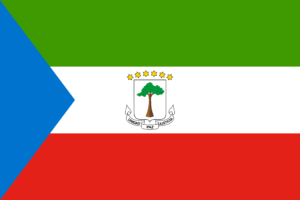
The flag of Equatorial Guinea consists of green, white and red horizontal stripes, with a blue triangle on the left and the coat of arms in the center. Blue stands for the sea, green for plants, white for peace, and red for the blood shed during the liberation struggle.
The coat of arms includes a silk-cotton tree (also known as the Tree of Heaven), Spain’s motto “Unity, Peace and Justice”, and six gold stars representing the five main islands and the mainland. I’m here.
After the 1995 oil spill, Equatorial Guinea became one of the largest oil producers in sub-Saharan Africa. However, most of the population still lives in poverty.
Equatorial Guinea has one of the lowest life expectancy in the world. As of 2021, life expectancy is just 58.4 years, the 10th lowest in the world.
What is unusual is that the current capital, Malabo, is located on the island of Bioko. Bioko is located 100 miles (160 kilometers) northwest of mainland Equatorial Guinea.
A new capital called Cuida de la Paz (formerly known as Oyala) is under construction on the mainland near Jibrojo. In 2017, President Teodoro Obiang officially moved the government of Equatorial Guinea to the unfinished Cuidad de la Paz (Oyala).
Malabo is named after Malabo Ropero Malacca (1837-1937), the last king of the Bubi tribe, an ethnic group native to Bioko Island. The new capital’s name, Cuidad de la Paz, means “City of Peace” in Spanish.
The small village of Ureka in Equatorial Guinea is the wettest place in Africa and one of the wettest in the world. It receives up to 10,450 mm (411 inches) of rain per year.

