History of Burundi:
Since the 15th century, Burundi has been ruled by a king named Mwani. Mwani ruled and owned all the land in this country. Farmers cultivate the land and pay taxes and tribute to the king. The king will protect you. The first European he arrived in Burundi in 1856. They didn’t stay there at that point. It was not until 1899 that Germany took control of Burundi. Belgium then occupied the area in 1916. Burundi had his two main political parties, the National Progressive Union (UPRONA) and the Christian Democratic Party (PDC).
Burundi became independent on 1 July 1962. First, it was a constitutional democracy founded by Mwambhutsa IV. However, the country was very unstable as military leaders fought for power. The country continued to decline, plunging into a horrific civil war between two ethnic groups, the Hutus and the Tutsis, in the 1990s. The civil war ended in 2006 with more than 150,000 dead.
Information about Burundi:
| Capital | Bujumbura |
| Population | 411,578 (Source: 2023 worldometer) |
| Major Cities | Bujumbura (capital), Gitega, Bururi, Bubanza, Muyinga, Muramvya, Ruyigi, Rutana, Kayanza |
| Borders | Rwanda to the north, Tanzania to the east and south, and the Democratic Republic of the Congo to the west |
| Gross Domestic Product (GDP) | $3,073,414,678 (2022 worldometer) |
| Currency | Burundi franc (BIF) |
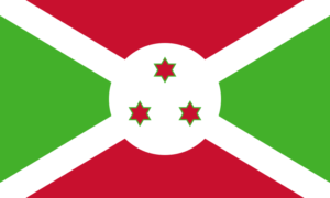
Flag of Burundi:
Burundi Economy Key Industries:
Burundi Major Industries: light consumer goods such as blankets, shoes, soap; assembly of imported components; public works construction; food processing
Burundi Agricultural Products: coffee, cotton, tea, corn, sorghum, sweet potatoes, bananas, manioc (tapioca); beef, milk, hides
Burundi Natural Resources: nickel, uranium, rare earth oxides, peat, cobalt, copper, platinum, vanadium, arable land, hydropower, niobium, tantalum, gold, tin, tungsten, kaolin, limestone
Burundi Major Exports: coffee, tea, sugar, cotton, hides
Burundi Major Imports: capital goods, petroleum products, foodstuffs
The Geography of Burundi:
Total Size of Burundi: 27,834 km² (source: wikipedia)
Geographical Low Point of Burundi: Lake Tanganyika 772 m
Geographical High Point of Burundi: Heha 2,670 m
Climate of Burundi: equatorial; high plateau with considerable altitude variation (772 m to 2,670 m above sea level); average annual temperature varies with altitude from 23 to 17 degrees centigrade but is generally moderate as the average altitude is about 1,700 m; average annual rainfall is about 150 cm; two wet seasons (February to May and September to November), and two dry seasons (June to August and December to January)
General Terrain of Burundi: hilly and mountainous, dropping to a plateau in east, some plains
World Region or Continent of Burundi: Africa
Geographical Coordinates: 3 30 S, 30 00 E
The People of Burundi & Culture
Burundi Government Type: republic
Burundi Nationality: Burundian(s)
Burundi National Holiday: Independence Day, 1 July (1962)
Burundi Independence: 1 July 1962 (from UN trusteeship under Belgian administration)
Burundi National Symbol: lion
Burundi National Anthem or Song: Burundi Bwacu (Our Beloved Burundi)
Burundi Languages Spoken: Kirundi (official), French (official), Swahili (along Lake Tanganyika and in the Bujumbura area)
Burundi Religions: Christian 67% (Roman Catholic 62%, Protestant 5%), indigenous beliefs 23%, Muslim 10%
Interesting Facts about Burundi:
Part of Burundi is home to Lake Tanganyika, the world’s longest freshwater lake. In addition, Lake Tanganyika is he second oldest freshwater lake in the world and also the second deepest lake. In both cases, it is the second largest by volume, after Lake Baikal in Russia.
About half of Burundi’s area is hilly and mountainous. Burundi’s average elevation is 1,504 m (4,934 ft) above sea level. The mountains of Burundi are located in the western part of the country and form part of the watershed between the Nile and Congo river basins.
Located in the highlands of Burundi about 20 kilometers (12 miles) east of Lake Tanganyika, Mount Heha is Burundi’s highest mountain at 2,684 m (8,806 ft).
Lake Tanganyika is the longest freshwater lake in the world, second in depth and second in volume. It is also the second largest of the Great Lakes of Africa, after Lake Victoria.
Burundi is home to the man-eating crocodile Gustave, who has killed hundreds. The crocodile lives in Lake Tanganyika and is said to be over 60 years old. Hundreds were attacked between 1987 and 2009. It is unknown if he is still alive.
In Burundi, the cow is a symbol of happiness, health and prosperity. A common greeting in Kirundi is ‘amasho’, which means ‘may your herds be abundant’. The answer is ‘Amasongole’, which means ‘May there be many herds of female cows’.
East Africans, especially Burundians, are known for brewing banana beer. Beer he often drinks several times with straws from one large container.


