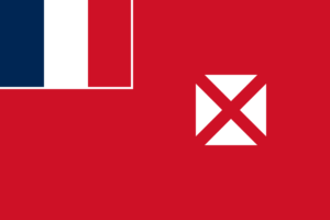
Wallis and Futuna is a French overseas territory. Islands in the South Pacific. The islands were first discovered by the Dutch in 1616. The French first settled the island and claimed it as a protectorate in 1842. They ruled Wallis and Futuna for the next 40 years. During World War II, US forces occupied the island. It became an overseas territory in 1961.
| Capital | Mata-Utu (on Ile Uvea) |
| Population | 11,491 (Source: 2023 worldometer) |
| Major Cities | Mata-Utu (on Ile Uvea) (capital), Liku, Alele, Falaleu, Utufua, Vaitupu, Akaka |
| Borders | Tuvalu to the northwest, Fiji to the southwest, Tonga to the southeast, Samoa to the east, and Tokelau to the northeast |
| Gross Domestic Product (GDP) | $60,000,000 |
| Currency | Comptoirs Francais du Pacifique franc (XPF) |

Wallis and Futuna Major Industries: copra, handicrafts, fishing, lumber
Wallis and Futuna Agricultural Products: breadfruit, yams, taro, bananas; pigs, goats; fish
Wallis and Futuna Natural Resources: NEGL
Wallis and Futuna Major Exports: copra, chemicals, construction materials
Wallis and Futuna Major Imports: chemicals, machinery, passenger ships, consumer goods
Total Size of Wallis and Futuna: 260 km (source: 2022 wikipedia)
Geographical Low Point of Wallis and Futuna: Pacific Ocean 0 m
Geographical High Point of Wallis and Futuna: Mont Singavi 765 m
Climate of Wallis and Futuna: Tropical; hot, rainy season (November to April); cool, dry season (May to October); rains 2,500-3,000 mm per year (80% humidity); average temperature 26.6 degrees C
General Terrain of Wallis and Futuna: volcanic origin; low hills
World Region or Continent of Wallis and Futuna: Oceania
Geographical Coordinates: 13 18 S, 176 12 W
Wallis and Futuna Government Type: NA
Wallis and Futuna Nationality: Wallisian(s), Futunan(s), or Wallis and Futuna Islanders
Wallis and Futuna National Holiday: Bastille Day, 14 July (1789)
Wallis and Futuna Independence: none (overseas territory of France)
Wallis and Futuna National Symbol: red saltire (Saint Andrew’s Cross) on a white square on a red field
Wallis and Futuna National Anthem or Song: note:?as a territory of France, La Marseillaise is official (see France)
Wallis and Futuna Languages Spoken: Wallisian 58.9% (indigenous Polynesian language), Futunian 30.1%, French 10.8%, other 0.2% (2003 census)
Wallis and Futuna Religions: Roman Catholic 99%, other 1%
Wallis and Futuna are French islands in the South Pacific in Oceania.
Its nearest neighbors are Tuvalu to the northwest, Kiribati to the north, Tokelau to the northeast, Samoa to the east, Tonga to the southeast, and Fiji to the west and southwest.
Wallis and Futuna had a population of 15,561 in 2014.
The capital is Matautu, with an area of 60 square kilometers and a population of 1,191 (2003).
The name Wallis was named after Cornish explorer Samuel his Wallis.
Wallis and Futuna has a tropical climate with four seasons. November to April are hot and rainy, and May to October are cool and dry, with an average temperature of 26.6°. Oh yeah, gorgeous!
This piece of paradise has 129 kilometers of coastline and sandy beaches that separate the sea from forests and low hills, perfect for swimming, hiking, sunbathing and exploring.
The average life expectancy here is 79 years.
The currency of Wallis and Futuna is the CFP franc. Have a cocktail ready.
The official language of Wallis and Futuna is French.
Yams, taro, sweet potatoes, breadfruit, cassava and fish are co-produced on the islands.
Not surprisingly, the country’s industry mainly consists of tourism.
We export copra, chemicals and building materials.

